Topic: The topic of this lesson is landforms. It is the first lesson of the unit and so it is an introduction to the topic. We will be identifying nine different kinds of landforms and their characteristics.
Rationale: This lesson will allow the students to learn about the world outside of just their classroom. Most of the time, students are so focused on what is going on within the walls of their home or their school that they do not pay attention to their surroundings. Landforms are something that children should be aware of. They are a part of our planet and so children should be aware of what landforms are and know some specific landforms. Being aware of your surroundings is a very important skill for students to learn and they will begin to gain this skill through this lesson on landforms, which they will then be able to apply to the rest of their lives and build on their observation skills.
Prior Knowledge: For this lesson, the students will need to know a general definition of what a landform is. We will expect the students to already know what a landform is so that we will be able to teach them about specific landforms (river, mountain, island, valley, etc.) Some misconceptions the students may have coming into this lesson are that landforms only include famous landforms and not the simple ones that surround them such as lakes and rivers in their area. The biggest misconception students will have is that the term “landforms” only applies to things on land. They may not realize that things like rivers and lakes can also be considered landforms. Their imaginations will be captured by trying to picture these landforms in their head and think of places they know where they can see these landforms.
NJ Standards:
6.6.B.1 Describe the physical features of places and regions on a simple scale.
6.6.B.2 Describe the physical and human characteristics of places.
Objectives
Students will be able to identify and name landforms.
Students will be able to identify the characteristics of specific landforms.
Assessments
When shown a picture of a landform, students will identify its name.
When shown a picture of a landform or told its name, students will be able to list the characteristics of that specific landform.
Hook: For the hook of this lesson, we will make a list of all of the landforms students can think of. The class will be down on the carpet and we will have the whiteboard next to us. Students will raise their hand and we will call on them one by one to give us an example of a landform. We will write these on the white board. We will repeat this until the students cannot come up with any more landforms.
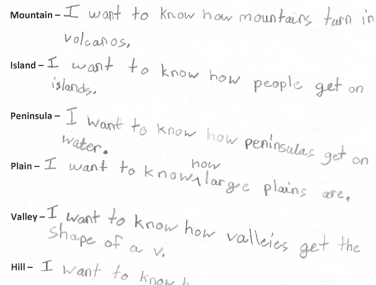
Activities, Questions, Examples, and Groups: To begin the lesson, we will bring the students down to the carpet. We will call them down based on who is sitting quietly and ready. The students have assigned seats on the carpet. Once they are sitting correctly and quietly, we will do the hook of our lesson. Next, we will introduce a KWL chart to the class and explain that is a chart we use to write down what we know about a topic and what we want to know before a lesson, and then we revisit it after a lesson to record what we have learned about that topic.
For each of the landforms, we will have a poster with a picture of that landform on the front. On the back of the poster will be the name of the landform and a description of it with a list of its characteristics. We will only show the students the front of the poster with the picture on it. First, we will talk about what we see in the picture and use that to fill out a KWL chart for the landform. Then we will have the students guess what the name of it is. After we have identified the landform, we will turn the poster over and go over its name and characteristics. After that, we will fill in the L column of our KWL chart for that specific landform. We will continue to do this same process for each landform. We will then tests the students’ comprehension by showing the picture-side of the posters again, in a different order, and having the class raise their hands quietly to volunteer the name of the landform in the picture or some details about it that we included on the back of the poster.
Once we are sure that the students are secure in their knowledge of each of the landforms we went over, we will introduce an expert group project to them and explain it to the class. We will tell the class that they will be split up into three groups and that each group will research a different landform that we have chosen for them. Each person will have a different job for their group so that two people are webquesters, two people are researchers, two people are storytellers, and one person is the illustrator. We will simply explain the management and directions of the expert groups today and we will work on the expert groups for the next two days.
Closure: For the closure of our lesson, we will have a discussion on all of the landforms we talked about that day. We will review each landform using the flashcards. Some possible ways we can do this are by showing the class the picture of a landform and asking for the name, showing a picture and asking for characteristics, telling the students a name of a landform and asking for characteristics, or telling the students characteristics of a landform and asking for its name.
Materials: posters of landforms (front will be a picture of the landform and back will be its name and a brief description/list of characteristics), whiteboard, expert group handout
Individualization: This lesson incorporates several different methods of learning for the students. For our visual learners, the poster flashcards will be very helpful. They will be able to see what the actual landform we are discussing looks like and get a real-life picture of it, instead of just hearing it described. It will also help them to see the name of the landform and its characteristics in big, clear letters on the back of the poster so that in their minds they will be able to connect this to the picture of the landform that they were shown. For our auditory learners, we will be giving tons of description and having a lot of discussion on the landforms we talk about. If they have trouble with look at pictures or reading descriptions, they will be able to listen to us describe each landform as we go over them and picture them in their mind as we talk about them. For the learners that like writing or reading, the KWL chart and our list of characteristics on the posters will be most helpful for them. They will be able to read the back of each poster to gain an understanding of the landform pictured on the front. With the KWL chart, the students will be able to map out exactly what they know about each landform and exactly what they learned once we go over each one. This incorporates visual learning as well as writing and provides repetition of the concepts we are learning to really instill the topic and its contents within the minds of our students.
Follow-Up Activities: Future lessons on this topic will include more in-depth looks at each specific landform.
